Why Was the Caminito del Rey Built?
Built from 1901 so hydroelectric workers could cross the Gaitanes Gorge: the King's walk in 1921, the deaths and closure, the 2015 rebuild and what is left.
The Caminito del Rey was built as a works path for a hydroelectric company. The Sociedad Hidroeléctrica del Chorro owned two power plants at either end of the Gaitanes Gorge, the Salto del Gaitanejo and the Salto del Chorro, and needed a way between them for its maintenance men, its materials and its watchmen. The path went up between 1901 and 1905, pinned to cliffs more than 300 metres high. It took its name, “the King’s little path”, after King Alfonso XIII walked it in May 1921 to open the dam upstream.
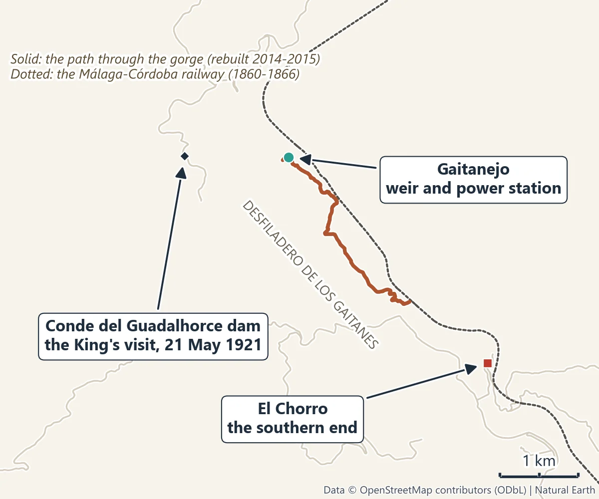
A path for a power company
The railway came first. The Málaga to Córdoba line was dug through the gorge between 1860 and 1866, and its trains still run along the left bank at almost the same height as the Caminito. Water was next. On 24 November 1902 Jorge Loring Heredia was granted the concession to harness the river’s fall, and on 26 July 1903 the engineer Rafael Benjumea founded the Sociedad Hidroeléctrica del Chorro to pay for the scheme.
The company’s water channel started at a small diversion weir at Gaitanejo, at the northern end of the gorge, and delivered the river to its power plant at El Chorro. Men had to inspect and repair that channel, carry materials along it and keep watch over it, and the gorge gave them no way through. So the company built one: a narrow walkway fixed to the rock face, running beside and over the channel itself. Work began in 1901 and finished in 1905, and the plant at El Chorro went into service in 1906.
The Gaitanes Gorge is the reason it looked the way it does. Its walls rise more than 300 metres and in places stand less than 10 metres apart, and the path ran on average 100 metres above the river, 105 at its highest.
Who built it
Benjumea supervised the works himself. The first stretches of the walkway were put up in 1901 not by labourers but by sailors, men used to working far from solid ground. The first boards were wooden; under Benjumea they were later replaced with concrete, in the years before the King’s visit.
Why it is called the King’s little path
Benjumea’s next project was a dam upstream, approved in August 1914, to hold back the Guadalhorce. On 21 May 1921, in torrential rain, King Alfonso XIII laid the last stone of the dam, and walked the aerial path to see the works. A stone chair and a carved stone table had been made for the ceremony; the chair, the Sillón del Rey, still stands by the dam, and the shuttle bus to the walk stops beside it. From that day people began to call the walkway the Caminito del Rey, the King’s little path. The dam took the name the King gave its builder: Alfonso XIII made Rafael Benjumea Count of Guadalhorce.
How it became the most dangerous walkway in the world
The company merged into Sevillana de Electricidad in 1967, and by the end of the century the path had lost its industrial role. It was abandoned and nobody maintained it. Handrails went missing, whole sections of the concrete floor broke away, and in places nothing was left but the steel beam that had held it up. That is the path that earned the nickname “the most dangerous walkway in the world”.
In 1999 and 2000 fatal accidents killed four people. One hiker fell to his death in December 1999. In August 2000 three young men died together when the anchor of an old cable they were using as a zip-line gave way. The Junta de Andalucía closed the ways in and demolished the path’s first section, and anyone caught trespassing faced a €6,000 fine.
Some accounts give five deaths for those two years; the official history counts four.
The rebuild, and the reopening in 2015
The Diputación de Málaga, the provincial government, launched a design competition in 2008, won by a team led by Isabel Bestué and Alfonso Bermejo, whose project was delivered in December 2010. The crisis stalled it, and when building finally started in 2014 the works were directed by the Diputación’s own architecture service under Luis Machuca, to a design that departed a good deal from the competition project. They were paid for by the Diputación and backed by the councils of Álora, Antequera and Ardales, the Junta de Andalucía and several ministries. The Diputación put €5.5 million into the project, €2.23 million of it for the new walkway and the rest for access paths and facilities.
The method was the remarkable part. Helicopters lifted ready-made sections into the gorge, and climbers on ropes fixed them to the rock. The new walkway, of wood and stainless steel, was laid above the old one rather than on top of it, so the original path survives underneath; the architects designed it so that it could be taken out again. The work added a glass-floored balcony and a hanging footbridge strung wall to wall across the gorge, 35 metres long and 105 metres above the river.
On 28 March 2015 the Caminito del Rey opened to the public again. Elías Bendodo, the president of the Diputación, inaugurated it with the mayors of Álora, Ardales and Antequera, and the first visitors walked it the same day. It drew 304,000 visitors in its first year, and more than 3.3 million in total by June 2026. On 10 June 2026 a second, 110-metre suspension bridge opened at the southern end, which shortens the walk out to El Chorro; the old path down stays open for anyone who prefers it.
What is left of the old path
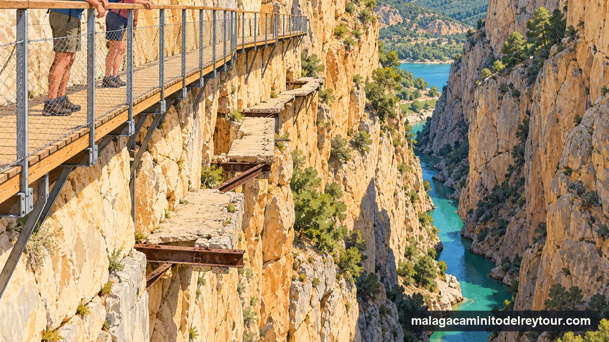
A good deal, because the rebuild set out to keep it. As you walk you look down on the remains of the old concrete path, the “balconcillos” or little balconies built in 1905, with the gaps and bare beams that made it notorious. The railway still runs through the gorge, and the Gaitanejo reservoir, where the water channel began, lies beside the north control booth, where every walk starts today. The whole gorge has been a protected natural area, the Paraje Natural Desfiladero de los Gaitanes, since 1989.
Hear it from a guide
You can walk the Caminito with only a ticket and the information boards, and plenty of people do. But this is a story told best on the spot: the channel you are standing over, the bare beams below, the dam where the King sat. That is what a guide adds. The Caminito’s own official guided visit costs €18 and is sold on its website. If you are coming from Málaga, the Caminito del Rey Guided Tour & Welcome Pack from Málaga by Áloratur/Caminito Travel pairs an official guide with the coach and your ticket, from $67 a person in current promotion (usually $80) (checked October 2026).
See the guided walk from Málaga
Before you go, read which entrance you start from and how the shuttle bus works, what the walk is like today and how tickets and prices work.
Quick answers
Why was the Caminito del Rey built? To let the hydroelectric company’s workers move between its two plants at either end of the Gaitanes Gorge, to maintain the water channel, carry materials and keep watch.
Who built it, and when? The Sociedad Hidroeléctrica del Chorro, founded by the engineer Rafael Benjumea, who supervised the works. Construction ran from 1901 to 1905.
Why is it called the Caminito del Rey? King Alfonso XIII walked it on 21 May 1921, when he came to finish the Conde del Guadalhorce dam. From then on people called it the King’s little path.
How many people died on the Caminito del Rey? Four people died in accidents there in 1999 and 2000, one in a fall and three on an old cable used as a zip-line. The way in was closed and demolished, and walkers came back only when the rebuilt walkway opened on 28 March 2015.
Is the Caminito del Rey scary today? It is high, with boardwalks more than 100 metres above the river and a hanging bridge, but the walk you do today is a new structure built in 2014 and 2015. The official site advises people with vertigo against it.
Sources
Written 30 October 2026, updated 31 October 2026. Dates, purposes and the official account of the deaths and the closure are from the Caminito del Rey’s official history (caminitodelrey.info) and the Diputación de Málaga’s heritage page; the 2008 competition and its winning project from the University of Granada team that wrote it; the reopening and the restoration from the Instituto Andaluz del Patrimonio Histórico and Arquitectura Viva; the 1999 and 2000 accidents from El País; costs, the inauguration and visitor numbers from La Opinión de Málaga, El País and El Español; the builders and the restoration method from Diario Sur. Tour details are from the tour’s GetYourGuide listing, read in October 2026.
Walk it with the story
More Ways to Walk the Caminito del Rey
Guided walks, tickets and day trips GetYourGuide sells for the gorge. Dates and cancellation terms are on each listing.
Hear the Story on the Walk Itself
A coach from central Málaga, your entry ticket and an official guide on the walk itself, with free cancellation up to 24 hours before.
Check Dates